Getting Real Column - 15
ink, similar to [10.] Almost as soon as the [10] map was completed
(some years ago), there were needs for changes, not readily done
on this inked drawing version.
One of my newmaps is shown in [19], for my town of Shumala.
(This is an actual Chumash Indian place name from the area.) Note
the stylistic similarities to both of the SP maps shown in [16] and
[18], though of course I do not show any numbers for tracks or
switches, since those were assigned years after my 1953 modeling
era. This is a Photoshop map; a test to see if I liked this map style.
The map does not show railroad structures such as the round-
house (to the left of the turntable [19]), because in and of itself,
that’s not a switching destination. But the machine shop at the left
rear of the roundhouse, as the map shows,
is
a switching location.
Likewise, the sand house and the “SP Fuel Spot” are where sand
and locomotive fuel are unloaded for use at this engine terminal.
This particular map only has one instance where specific spots are
identified, at the Associated Oil Company bulk dealer. But other
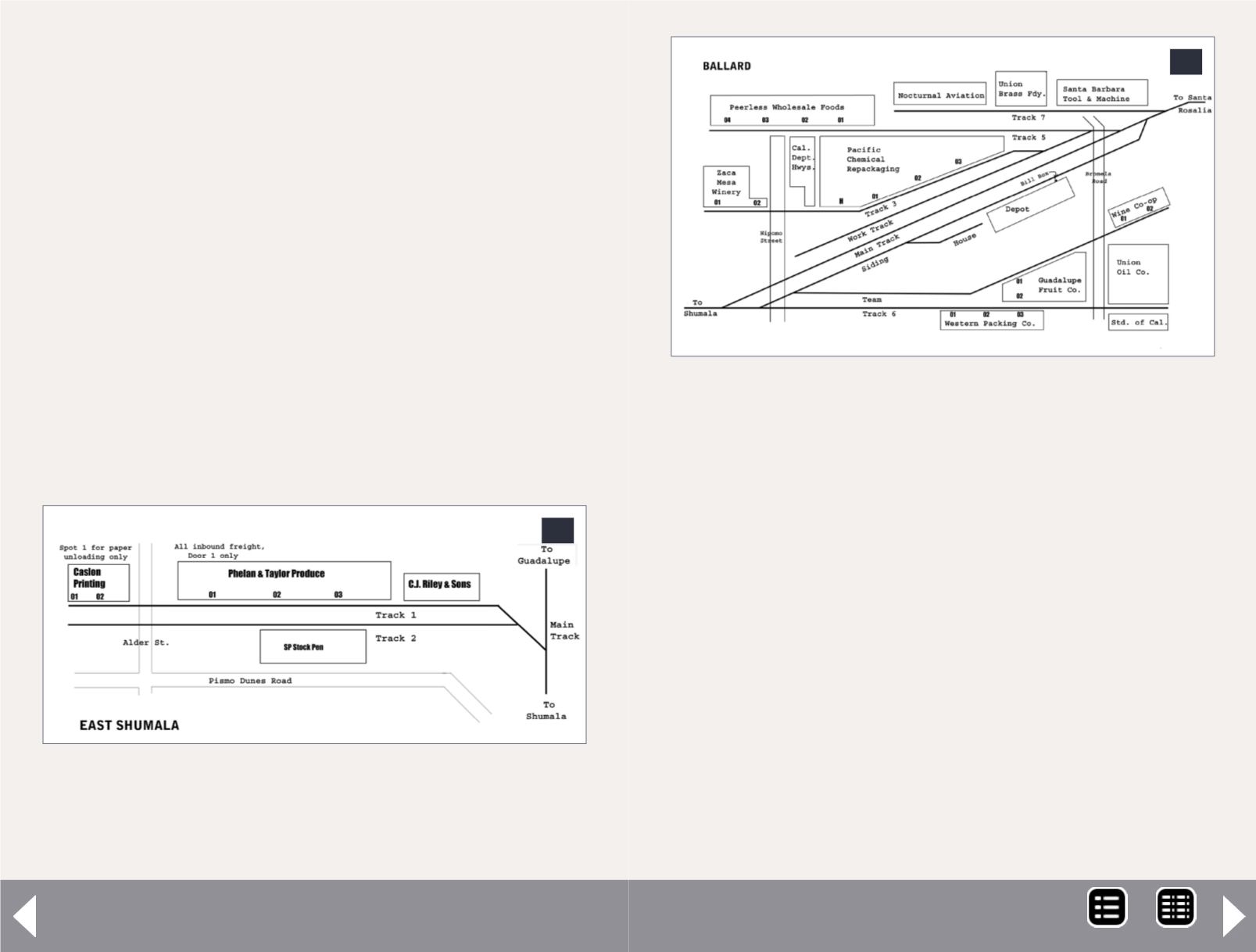
20. Map for the layout timetable of the location called
East Shumala. Here there are specific spots at two of
the industries. Surface roads are also shown, as this
helps operators locate specific points.
20
towns are different; I will show examples in a moment. Note that
in [19] there is a track at lower left, labeled “To East Shumala.” The
map is done this way partly to suggest that East Shumala is some
ways away from the town depicted in [19], but partly also because
it physically lies about perpendicular to Shumala on the layout,
thus not being geometrically convenient to be represented in a
map like [14].
That in turn means that a separate map in the timetable was pre-
pared for East Shumala. That area is itself simple to represent, but
as stated, the separate map helps convey some conceptual dis-
tance. This strategy could be used on many layouts. My map for
East Shumala is shown in [20], and here open boxes instead of gray
rectangles are used for structures (partly as an experiment relative
21. My current map of Ballard, which is still undergo-
ing occasional revision. Not only are there a number of
industries here, but many have multiple spots. These
are called out on most waybills. If the specific spot is
not designated on the waybill, crews would receive
direction from the local agent or from a plant foreman.
21
MRH-Oct 2014


